Region: Galicia
Country: Spain
Website: http://www.xunta.es/portada
Partner in charge of the site: CIF
Responsible name: Francisco Javier Silva Pando
Site characteristics
Altitude (m): 480Topography: middle slope
Orientation: W
Slope (%): 30.0
Hydrology: Middle slope in the river Lerez basin and 20 km far from Atlantic coast
Soil type: UMBRISOLS
Soil sub-type: cambic
Parent rock: acid regional metamorphic rocks
PH: 4.6
Climate
Average temperature (°C): 12.3Average precipitation (mm): 1673
Number of frost days: 37
Reference period for climatic data: 2005-2012
History of the site
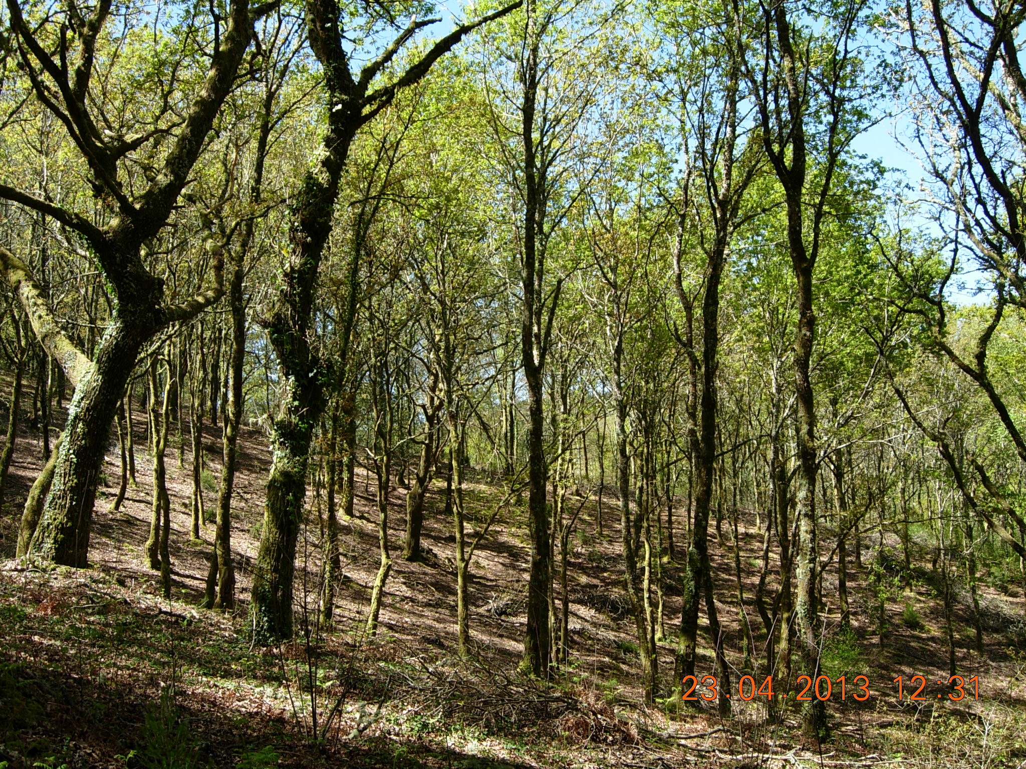
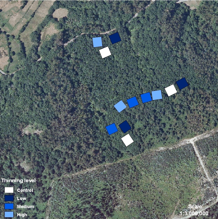
The stand shows an uneven-aged oak (Quercus robur L.) canopy covering a sparse understory mainly with grasses and some shrubs (holly trees, chestnuts, heaths and gorses). Initially, tree stand characteristics were: Age (32 years), Mean DBH (22.5 cm), Mean Height (14.8 m), Density (1000 tree/ha) Thinning treatments were applied in 1999. The stand is surrounded by pastures and orchards and occasionally some trees were removed mainly for fuel by the nearest neighbors. DS07 is placed on a private land. The land is owned and managed by a Neighborhood Forest Association, typical of Galician culture. All the forest area belongs to a territorial demarcation, “parroquia”, which joins all the neighborhood members. Each citizen owns a percentage of the whole indivisible forest area and the management must be agreed with all the members of the community by a common consent. In Galicia, this way of forest property is called “Neighborhood Forest in Common Hand”. We asked for the permission to the Neighborhood Forest of Loureiro, and they, by common consent, gave us a permission to establish the experience.Publications related to the site
6121937
DS07
1
apa
50
default
2564
https://reinfforce2.plantedforests.org/wp-content/plugins/zotpress/
%7B%22status%22%3A%22success%22%2C%22updateneeded%22%3Afalse%2C%22instance%22%3Afalse%2C%22meta%22%3A%7B%22request_last%22%3A0%2C%22request_next%22%3A0%2C%22used_cache%22%3Atrue%7D%2C%22data%22%3A%5B%7B%22key%22%3A%22EP4M9RKE%22%2C%22library%22%3A%7B%22id%22%3A6121937%7D%2C%22meta%22%3A%7B%22creatorSummary%22%3A%22G%5Cu00f3mez-Garc%5Cu00eda%20et%20al.%22%2C%22parsedDate%22%3A%222025-12-07%22%2C%22numChildren%22%3A0%7D%2C%22bib%22%3A%22%26lt%3Bdiv%20class%3D%26quot%3Bcsl-bib-body%26quot%3B%20style%3D%26quot%3Bline-height%3A%202%3B%20padding-left%3A%201em%3B%20text-indent%3A-1em%3B%26quot%3B%26gt%3B%5Cn%20%20%26lt%3Bdiv%20class%3D%26quot%3Bcsl-entry%26quot%3B%26gt%3BG%26%23xF3%3Bmez-Garc%26%23xED%3Ba%2C%20E.%2C%20Rozados%20Lorenzo%2C%20M.%20J.%2C%20%26amp%3B%20Silva-Pando%2C%20F.%20J.%20%282025%29.%20Modelling%20Growth%20and%20Yield%20Response%20to%20Thinning%20in%20Quercus%20robur%20L.%20Stands%20in%20NW%20Spain.%20%26lt%3Bi%26gt%3BForests%26lt%3B%5C%2Fi%26gt%3B%2C%20%26lt%3Bi%26gt%3B16%26lt%3B%5C%2Fi%26gt%3B%2812%29%2C%201831.%20%26lt%3Ba%20class%3D%26%23039%3Bzp-DOIURL%26%23039%3B%20href%3D%26%23039%3Bhttps%3A%5C%2F%5C%2Fdoi.org%5C%2F10.3390%5C%2Ff16121831%26%23039%3B%26gt%3Bhttps%3A%5C%2F%5C%2Fdoi.org%5C%2F10.3390%5C%2Ff16121831%26lt%3B%5C%2Fa%26gt%3B%26lt%3B%5C%2Fdiv%26gt%3B%5Cn%26lt%3B%5C%2Fdiv%26gt%3B%22%2C%22data%22%3A%7B%22itemType%22%3A%22journalArticle%22%2C%22title%22%3A%22Modelling%20Growth%20and%20Yield%20Response%20to%20Thinning%20in%20Quercus%20robur%20L.%20Stands%20in%20NW%20Spain%22%2C%22creators%22%3A%5B%7B%22creatorType%22%3A%22author%22%2C%22firstName%22%3A%22Esteban%22%2C%22lastName%22%3A%22G%5Cu00f3mez-Garc%5Cu00eda%22%7D%2C%7B%22creatorType%22%3A%22author%22%2C%22firstName%22%3A%22Mar%5Cu00eda%20Jos%5Cu00e9%22%2C%22lastName%22%3A%22Rozados%20Lorenzo%22%7D%2C%7B%22creatorType%22%3A%22author%22%2C%22firstName%22%3A%22Francisco%20Javier%22%2C%22lastName%22%3A%22Silva-Pando%22%7D%5D%2C%22abstractNote%22%3A%22Thinning%20is%20a%20key%20silvicultural%20practice%20for%20managing%20forests%3B%20however%2C%20its%20effects%20on%20stand%20growth%20and%20yield%20remain%20debated.%20This%20study%20evaluated%20the%20growth%20and%20yield%20responses%20to%20thinning%20in%20even-aged%20Quercus%20robur%20stands%20in%20Galicia%20%28NW%20Spain%29%20using%20data%20from%20three%20long-term%20thinning%20trials%20established%20between%201998%20and%201999.%20A%20randomised%20complete%20block%20design%20was%20applied%20with%20four%20thinning%20intensities%20from%20below%3A%20control%20%28C%2C%200%25%20basal%20area%20removal%29%2C%20light%20%28L%2C%2015%25%29%2C%20moderate%20%28M%2C%2035%25%29%2C%20and%20heavy%20%28H%2C%2055%25%29.%20Two%20complementary%20analytical%20approaches%20were%20implemented%20using%20linear%20mixed-effects%20models%3A%20a%20state-space%20approach%20examining%20post-thinning%20stand%20dynamics%20and%20a%20thinning-effect%20approach%20assessing%20the%20cumulative%20stand%20growth%20and%20yield%2C%20accounting%20for%20both%20standing%20and%20harvested%20components.%20The%20state-space%20analysis%20confirmed%20that%20thinning%20produced%20distinct%20stand%20structures%20in%20moderate%20and%20heavy%20treatments%20%28M%20and%20H%29%2C%20with%20the%20largest%20differences%20observed%20in%20the%20stand%20basal%20area%20and%20trees%20per%20hectare%2C%20while%20the%20dominant%20height%20remained%20unaffected.%20In%20the%20thinning-effect%20approach%2C%20the%20cumulative%20basal%20area%20and%20volume%5Cu2014excluding%20and%20including%20mortality%5Cu2014followed%20the%20pattern%20L%20%26gt%3B%20C%20%26gt%3B%20M%20%26gt%3B%20H.%20Overall%2C%20the%20results%20indicate%20that%20light%20or%20moderate%20thinning%20intensities%20maintain%20stand%20yield%20and%20enable%20intermediate%20harvests.%20At%20the%20same%20time%2C%20although%20the%20mean%20diameter%20increased%20under%20more%20intensive%20thinning%2C%20differences%20in%20the%20dominant%20diameter%5Cu2014approximating%20potential%20future%20crop%20trees%5Cu2014were%20not%20significant%2C%20indicating%20that%20stronger%20thinning%20from%20below%20did%20not%20necessarily%20enhance%20the%20development%20of%20the%20dominant%20trees.%22%2C%22date%22%3A%222025-12-07%22%2C%22section%22%3A%22%22%2C%22partNumber%22%3A%22%22%2C%22partTitle%22%3A%22%22%2C%22DOI%22%3A%2210.3390%5C%2Ff16121831%22%2C%22citationKey%22%3A%22%22%2C%22url%22%3A%22https%3A%5C%2F%5C%2Fwww.mdpi.com%5C%2F1999-4907%5C%2F16%5C%2F12%5C%2F1831%22%2C%22PMID%22%3A%22%22%2C%22PMCID%22%3A%22%22%2C%22ISSN%22%3A%221999-4907%22%2C%22language%22%3A%22en%22%2C%22collections%22%3A%5B%5D%2C%22dateModified%22%3A%222026-07-09T11%3A59%3A51Z%22%7D%7D%5D%7D
Gómez-García, E., Rozados Lorenzo, M. J., & Silva-Pando, F. J. (2025). Modelling Growth and Yield Response to Thinning in Quercus robur L. Stands in NW Spain. Forests, 16(12), 1831. https://doi.org/10.3390/f16121831
 copyrigth IEFC network